
 WATE 6 On Your Side
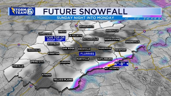
The coldest air of the season moves in tonight with snow showers and record-breaking cold weather being possible. • Tonight: (30%): Spotty snow showers. First widespread freeze with a breezy NW wind making it feel even colder. Low: 30°. • Tomorrow: (40%): (WINTER STORM WARNING FOR THE SMOKIES) Scattered snow, especially the higher terrain. Otherwise, frigid and blustery. High: 36°. • Tomorrow Night: Record cold low temperatures are possible. Low: 23° • Tuesday: Very cold morning with a slow warm-up. Mosty sunny and breezy. High:45°
Very cold temperatures and spotty snow showers will highlight the forecast for tonight. For those in the valley, some snow flurries will be around. Some minor accumulation is possible on cooler surfaces such as car and roof tops. There could be some iso

 WSIL-TV
 KNOE
KNOE FOX Weather
 WBRC
WBRC Hawaii News Now
 The Bay City Times
 KOLO8
KOLO8 NECN Providence
 CBS News
 21Alive News
 The Daily Beast