
 Hawaii News Now
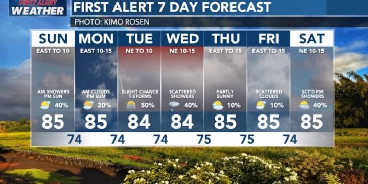
HONOLULU (HawaiiNewsNow) - Trade winds will weaken Sunday into Monday, with more showers in the forecast for Monday through Wednesday as a front approaches from the northwest.
The front may not actually reach the islands, but a trough is forecast to form ahead of it, along with an upper level low. These will combine to bring instability and increased moisture, especially for Hawaii Island.
Therefore, there’s a First Alert for more increased rainfall for the eastern end of the state, with a slight chance of thunderstorms. There’s still uncertainty over the forecast, but we should know more by late Sunday. Just be prepared for some wetter weather starting Monday night through Wednesday afternoon.
In surf, a small to moderate northwest swell will push waves up a bit for north and west shor

 Daily Voice
 NBC Connecticut
 WABI
WABI WREX
WREX Fox 11 Los Angeles Sports
 FOX 26 Texas
 13 On Your Side
 KEZI 9 News
 Northern News Now
 Newsweek Top