
 Eyewitness News 3
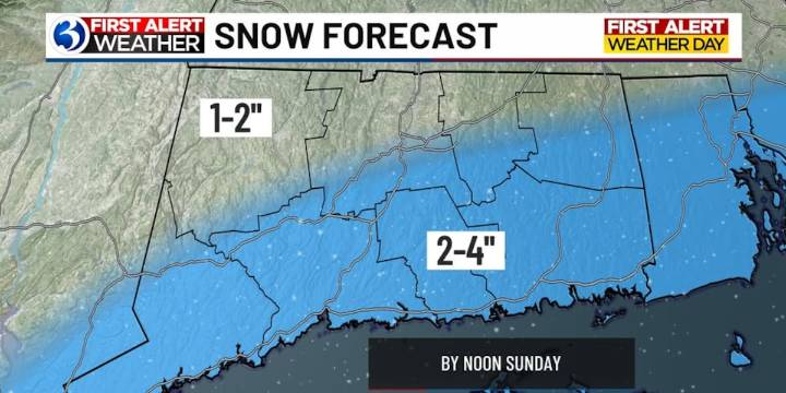
For any Alerts in effect for CT, click: here .
THIS EVENING THROUGH TOMORROW...
While the day has featured tranquil conditions, things become more active later this evening. Temperatures will start to drop, falling below freezing by 7 or 8 p.m. Thereafter, snow showers will develop as low pressure forms south of Connecticut. The showers will be scattered in nature at first, becoming steadier as the night goes on. It may be moderate at times in southern CT while northern CT sees lighter snowfall rates. Snow winds down by the middle of Sunday morning, wrapping up entirely by 10 a.m. Totals will end up in the 2-4″ for towns southeast of I-84. Shoreline communities have the highest chance of receiving 4″. For towns northwest of I-84, expect 1-2″. The snow will be light and fluffy, fairly e

 USA TODAY National
 WAND TV
 The Washington Post
 WTOP
WTOP NBC Chicago
 ABC6 Rhode Island
 New York Post
 NBC Connecticut
 WOWT
WOWT