
 WHAS 11
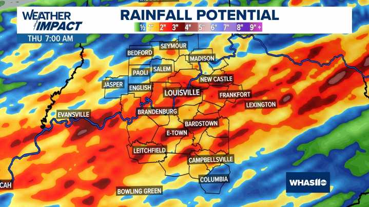
KENTUCKY, USA — The drought-busting rain that has been falling this week is expected to ramp up again Tuesday night through Wednesday night. With the ground now more saturated, it will not take as much rain to create a flooding threat during this next round of showers and storms.
The Weather Prediction Center has included much of our viewing area in a “Slight” Risk (yellow) for excessive rainfall Tuesday night through Wednesday night. This translates to “at least a 15% chance of rainfall exceeding flash flood guidance within 25 miles of a point”.
Credit: WHAS Excessive Rainfall Outlook Tuesday Night
Credit: WHAS Excessive Rainfall Outlook Wednesday
If a Flash Flood Warning is issued for your area, remember, “Turn around, don’t drown!”. Never drive through flooded roadways and be ex

 KICKS 105
 FOX 5 Atlanta Crime
 AccuWeather Severe Weather
 KRIS 6 News Weather
 KPTV Fox 12 Oregon
 KTVU San Francisco
 WFTV Channel 9
 KGNS
KGNS KSNB Local4 Central Nebraska
 The Spectator