
 WKYT
WKYT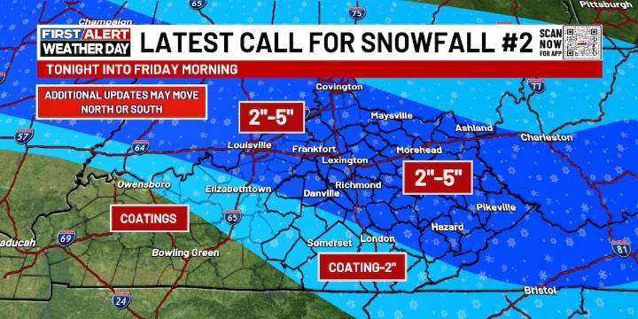
LEXINGTON, Ky. (WKYT) - We are headed into another First Alert Weather Day here in Kentucky, as our next snow system shows up later tonight. Keep your snow shovels ready and stay bundled up as we head towards the weekend!
Thursday daytime stays calm, with a few flurries showing up. Temperatures feel plenty colder in our skies, with highs peaking in the low to mid-30s.
A low pressure region is sliding southeast out of Missouri into Tennessee tonight, and that track will be key for where the heaviest snow sets up. Along and just north of the low’s path, a healthy swath of snow is expected to develop, stretching in a corridor where widespread totals of 2 to 5 inches look likely.
A sharp southern cutoff will define the edge of the snow band, oriented northwest to southeast, meaning some are

 WNNY-TV
 WSAZ NewsChannel 3
 WAVE 3 News
 Raw Story
 Associated Press Top News
 KFDA-TV Sports
 AlterNet
 Vogue Fashion
 Breitbart News
 WYMT Sports